http://cartinafinland.fi/en/imagebank/image/84/84223/Andes%2Bmountains,%2BArgentina.%2B84223.jpg&imgrefurl
The Andes continue to grow as the lithosphere begins "rafting" on the asthenosphere.
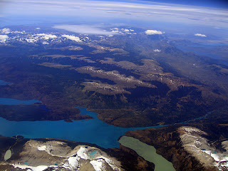
Caption: A aerial view shot of Patagonia taken from Chile.
http://en.wikipedia.org/wiki/File:Patagonia_aerial.jpg
Caption: The picture above shows a fault-line scarp of a normal fault in the Andes.
This normal fault was formed by the process of extension.
http://www.google.com/imgres?imgurl=http://ic.ucsc.edu/~casey/eart150/Lectures/3NormStrkSlpFlts/AndesNrmlFlt.mod.jpg&imgrefurl
The Copahue Volcano below is an active stratovolcano. It is composed of andesite and has a composite cone with a caldera of twelve miles in diameter. Since this volcano is near a lake, many geysers exist due to the geothermal activity. During an eruption, this stratovolcano expels lava with high viscosity. In the last eruption of Copahue, pyroclastics such as tephras, cinders, and bombs were emitted. Being near the eruption, locals and tourists inhaled this dangerous ash. With this volcano surrounded by snow, it is probable that there were lahars.
http://travellingboard.net/wp-content/uploads/2008/06/copahue.jpg
Caption Below: The video below gives a great 360 degree view at the solfatara field of the Copahue volcano and shows numerous, basalt-lava flows and dikes.
Caption Below: A great example of isostatic balance is shown in the glaciers near Patagonia.
http://www.google.com/imgres?imgurl=http://portraithouse.net/wp-content/uploads/2010/01/Perito_Moreno_Glacier_Patagonia_Argentina_Luca_Galuzzi_2005.jpg&imgrefurl
As the glacier recedes and the ice melts, the crust (lithosphere) shows isostatic rebound.
Below: Perito Moreno Glacier
http://www.google.com/imgres?imgurl=http://www.hostelbloggers.com/wp-content/uploads/2008/08/argentina-perito_moreno-glacier.jpg&imgrefurl
Works Cited
http://www.patagonia-argentina.com/i/
http://www.blueplanetbiomes.org/andes.htm
http://volcano.oregonstate.edu/vwdocs/volc_images/south_america/chile/copahue.html
http://www.volcanolive.com/copahue.html
http://science.jrank.org/pages/6300/South-America-Andes.html
http://www.wesleyan.edu/ees/JCV/vlsa1.html


Jordan,
ReplyDeleteI think the area you chose for your blog is beautiful and a great choice. The picture you selected for the normal fault line scarp created by extension is a great example of what Case showed us in his lecture. The triangular facets and wine glass valleys are obvious signs of the fault process you named. Your example for isostatic balance is also easy to visualize with the pictures you selected.
Jordan,
ReplyDeleteYour blog is very descriptive and provides a great illustration of The Andes Mountains. Your brief descriptions like the one of convergence and subduction helps to provide a better correlation between the images and terms. The clip of the Copahue Volcano is more interactive than just an image and helps to understand how the flows and dikes are formed. Overall your blog is clean, consistent, and easy to read. Good job!
Jordan,
ReplyDeleteYour region of choice lends itself well to the topics you cover in the post. The geographic diversity exhibited throughout is well-displayed and explained. I felt that the image of the fault-line scarp along the Andes illustrated the scale of extension particularly well. The amount of detail put into the explanation of each process, especially that of the rock types within the region's creation, is the strongest aspect of the post. Moreover, your use of media is great and effectively illustrates the material covered.
Jordan,
ReplyDeleteYou chose a very diverse landscape which would normally be hard to explain. You managed to apply the different forms and processes we learned in class to your landscape and do so very accurately and in an organized manor. All your pictures match perfectly with your discriptions of the land while also making the appeal of the Andes Mountains that much greater. Your description of the process formation of the mountains was direct and accurate while discussing the process of convergence and subduction. Over all, your blog was to the point and used very little excess wording which made it easy to read and very informational.